
Sectional mapping of land in Rasht is one of the most important engineering services for owners, builders and real estate investors in Gilan province, especially in the urban and semi-rural environment of this region. Due to its location in a humid area, the rapid growth of construction, the development of urbanization and the diversity of land use, Rasht has a high need for accurate and legal mapping. When it comes to dividing the land and determining the real and recordable boundaries in the registry office and municipality, it is necessary to have a separate land mapping in Rasht with high accuracy and standard mapping. The principled separation of land prevents the occurrence of legal problems, border disputes and capital loss and ultimately leads to an increase in the value of the property.
In such a dynamic urban environment, professional surveyors with advanced tools can carry out future constructions purposefully, legally and without errors. For this reason, the "Leading Mapping Engineering Office" using the most up-to-date equipment and experienced professionals, provides land separation mapping services in Rasht with the highest standard to give complete confidence to the owners and builders.
What is land mapping and what is its use?
The mapping of the land in Rasht is a process in which the land is divided into smaller and specific parts and each part has a precise border, a specific area and a defined legal position. The result of this process is a map that the owner can use to receive a single-sheet document, register at the registry office, submit to the municipality, or conduct secure transactions.
Important applications of land separation mapping in Rasht include the following:
• Legal registration and issuance of official document
• Determining the boundaries accurately to prevent conflict and property disputes
• Land preparation for construction
• The possibility of selling smaller pieces and more accurate valuation
• Preventing municipal problems and violation of property privacy
• Accurate understanding of the existing situation for the design of civil and construction projects
Due to the high humidity and the geographical changes of the land in Gilan, the accuracy of land mapping in Rasht becomes more important than in other areas. Any mistake, even a small one, in the separation can impose very heavy costs on the owner in the future.
Why does Rasht need detailed mapping?
Rasht has natural and urban features that increase the need for separate land mapping in Rasht compared to other cities in the country. The most important factors are:
• Humid climate that causes changes in the earth's surface, periodic settlements and displacement of natural boundaries.
• The rapid growth of residential and commercial constructions, which without accurate mapping can lead to border interference.
• Existence of inherited and old lands that often lack accurate documents.
• Expanding the outskirts of the city and changing land use, which directly requires the stabilization of the legal border.
• Differences in land use (residential, agricultural, commercial, industrial) that require different and accurate measurements.
All these cases show that land mapping in Rasht is not only a side job, but the basis of any legal and civil activity.
The stages of land mapping in Rasht
Segregation mapping of land in Rasht requires detailed planning and the use of professional tools. Its main steps are:
• Review of primary documents and ownership documents such as documents, banchag, sketch, existing status map
• Initial visit to the site and survey of topographical conditions
• Accurate survey of points and borders of the land with advanced equipment
• Analyzing data and converting the collected points into a separation map
• Land division based on the opinion of the owner, comprehensive plan and municipal regulations
• Determining the exact area of new parts
• Preparation of the final map that can be presented to the municipality and registration of documents
These steps should be done by an experienced mapping engineer so that the final document is legally and technically flawless. The leading mapping engineering office performs all these steps in full compliance with the standards of the country's document registration organization.
The equipment used in land separation mapping in Rasht
In order to increase the accuracy of separate land mapping in Rasht, the use of advanced tools plays a very important role. The equipment used includes the following:
• Two-frequency RTK GPS to determine current coordinates with centimeter accuracy
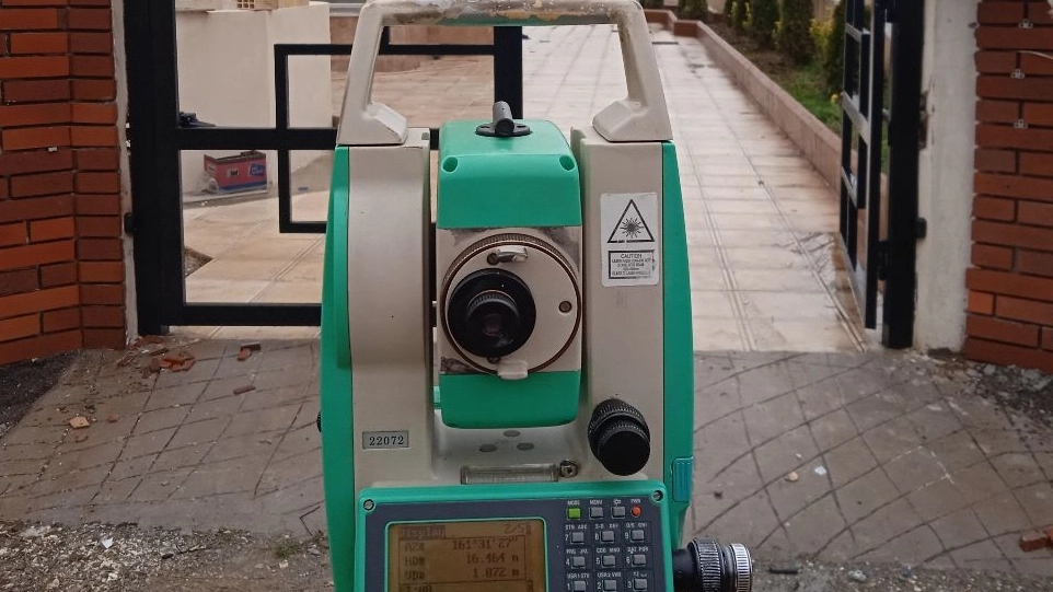
• Advanced total stations for accurate measurement of angles and distances
• Photogrammetric drone for aerial mapping and quick harvesting of large areas
• Laser scanner for high-precision 3D imaging
• Specialized mapping software such as Civil3D, ArcGIS, Leica Geo Office
Divisional mapping of land in Rasht with such equipment reduces errors, increases the speed of the project and produces accurate maps. The leading mapping engineering office uses all these tools in the projects of Rasht and its suburbs.
The advantages of using separate land mapping in Rasht
Divisional land mapping in Rasht has many advantages for the owner, engineer and buyer. Some of the most important advantages are:
• Prevent border and legal disputes
• The possibility of selling the property at a real price
• Speeding up the construction permit issuance process
• Receive a single sheet document for each piece
• Converting large land into smaller and profitable pieces
• The possibility of basic building design according to urban planning regulations
• Preventing unwanted encroachment on the neighbor's privacy
• Complete confidence in investment
In Rasht, which is one of the most popular areas for construction, the use of specialized land mapping services plays an important role in the success of projects.
How much is the cost of separate land mapping in Rasht?
The price of separate land mapping in Rasht varies based on various factors, including:
• Land area
• Number of desired parts
• Land location (urban, rural, steep, with difficult access)
• Type of equipment used
• Need for drone or ground collection
• Request to prepare UTM map or single sheet document
In general, the cost of separate land mapping in Rasht is very affordable compared to the final value and investment security. The leading mapping engineering office provides an accurate cost estimate before the work begins so that the owner can make a fully informed decision.
Why is the leading mapping engineering office the best choice for detailed land mapping in Rasht?
Foreign Mapping Engineering Office is one of the most reliable collections active in Rasht and Gilan province, which has many years of experience in separation projects, document preparation, registration mapping and UTM map preparation. The reasons for choosing this collection include:
• Use of advanced and up-to-date equipment
• The presence of experienced and qualified engineers in the engineering system
• Providing acceptable maps for municipality, document registration and agricultural jihad
• High speed in carrying out the project without reducing accuracy
• Reasonable and transparent cost
• Professional advice to receive a single-sheet document
• Full support until the final stage of legal registration
If your goal is to receive accurate and reliable land mapping services in Rasht, the leading mapping engineering office is a reliable and professional choice.
summary
Mapping of land in Rasht is one of the most essential engineering services for owners, builders and investors. Considering the rapid growth of Rasht city, the geological complexities of Gilan and the need for accurate legal registration, it is very important to do this work by professional experts. The use of advanced equipment, compliance with registration standards and the preparation of acceptable maps for the municipality are all factors that increase the value of this service.
Providing specialized, accurate and reliable services, the leading mapping engineering office is the best option for detailed land mapping in Rasht and can handle all the steps from the initial survey to legal registration.